RTA Dubai Metro Map Complete Guide
About Dubai Metro Map
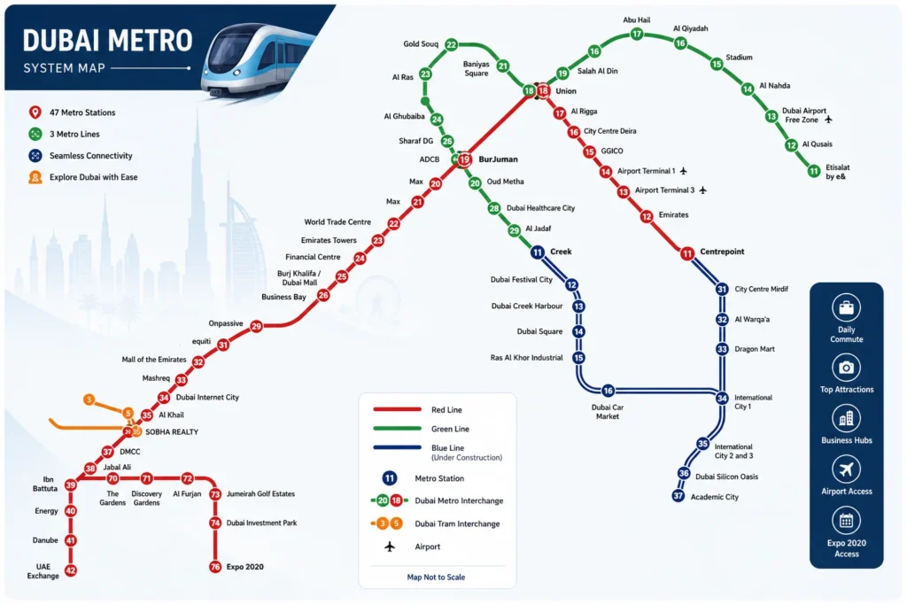
The Dubai Metro Map helps you explore the Dubai Metro, a modern rapid transit rail network in Dubai, United Arab Emirates (UAE). It makes route planning simple across the Red Line and Green Line, allowing you to plan your journey with ease. Whether you’re traveling through commercial areas or residential areas, the interactive map clearly displays every station and all stations across the metro system, public transport, railway, and transit network.
Understanding the Map
- Red Line: Runs from Centrepoint to Life Pharmacy, serving 35 stations across key destinations such as Dubai International Airport, Deira, Karama, Downtown Dubai, and Jebel Ali.
- Green Line: Connects Etisalat to Creek through 23 stations, including Deira, Al Qusais, Al Jadaf, and Healthcare City.
- Interchange Stations: Union and BurJuman connect the Red and Green lines, making it easy for passengers to transfer between routes.
- Zone System: The Zone System uses a zone-based fare system with 7 zones. Your fare depends on the number of travel zones, metro zones, route, station, and metro map you use.
Using the Interactive Map
Our interactive map makes it easy to navigate the Dubai Metro system with useful features:
- Zoom in or zoom out to view more details.
- Click any station to see station details, nearby attractions, and available facilities.
- Filter to display only Red Line or Green Line stations.
- Switch between map view and station list view.
- Search specific stations by station name for faster journey planning, easier route selection, and to explore Dubai more efficiently.
What is Dubai Metro Network?
The Dubai Metro is a world-class, fully automated rail system operated by the RTA. It forms the backbone of the city’s transport network, providing reliable public transport with seamless connectivity between residential hubs, commercial hubs, and Dubai International Airport (DXB) while improving urban mobility across Dubai.
Metro Lines
- Red Line: Runs along Sheikh Zayed Road, connecting Centrepoint, Downtown Dubai, and Expo City.
- Green Line: Serves the historic districts of Deira and Bur Dubai, linking important destinations across the city.
Passenger Features
- Free Wi-Fi: Available on trains and at metro stations for a connected journey.
- Safety: Protected by the Metro Police and more than 3,000 CCTV cameras, ensuring secure travel.
- Accessibility: Includes tactile guidance paths and lifts for People of Determination, making the metro network convenient for everyone.
Dubai Metro Red Line Map & Stations
From my experience, the Red Line is the main artery of the Dubai Metro and the easiest way to travel across the city. Since it opened on 9 September 2009, this 52.1 km rail line has become a vital part of the metro network, improving city connectivity, urban mobility, and public transport. The line starts at Centrepoint in Rashidiya (north east) and continues to UAE Exchange in Jebel Ali (south west), with the Route 2020 extension from Jabal Ali station to Expo City. Along the way, its 35 stations connect major business districts, malls, beaches, and Dubai International Airport, making every metro route convenient within Dubai’s rail network.
Red Line Service & Frequency
- Trains arrive every 3 minutes 45 seconds during peak hours.
- During off peak times, the train frequency is around 5 to 7 minutes.
- The Red Line handles the highest passenger volume across the network and metro network, especially during morning rush hours and evening rush hours.
- It is the preferred choice for commuters because of its reliable metro service, efficient rail service, shorter travel time, and well-connected transit system.
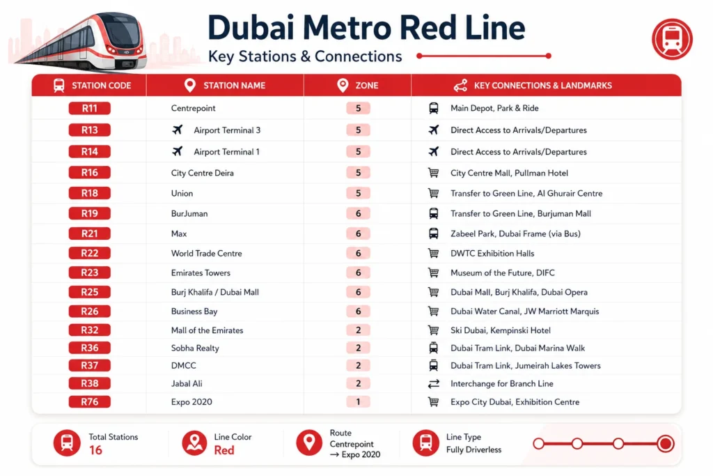
Red Line Main Branch Stations
Zone 7
📍 Centrepoint (formerly Rashidiya) — Northern Terminus
📍 Emirates
📍 Airport Terminal 3
Zone 6
📍 Airport Terminal 1
📍 GGICO
📍 City Centre Deira (formerly Deira City Centre)
📍 Al Rigga
📍 Union (Interchange with Green Line)
📍 BurJuman (Interchange with Green Line)
📍 ADCB
📍 Max (formerly Al Jafiliya)
Zone 5
📍 World Trade Centre
📍 Emirates Towers
📍 Financial Centre
📍 Burj Khalifa / Dubai Mall
📍 Business Bay
📍 ONPASSIVE (formerly Noor Bank)
📍 Equiti
Zone 4
📍 Mall of the Emirates
📍 Mashreq
📍 Dubai Internet City
📍 Al Khail (formerly Sobha Realty / Nakheel)
📍 Sobha Realty (formerly Dubai Marina / DAMAC Properties)
📍 DMCC (formerly Jumeirah Lakes Towers – JLT, Dubai Tram Interchange)
Zone 2
📍 Jabal Ali (Interchange with Route 2020 / Expo City Branch)
📍 Ibn Battuta
📍 Energy
📍 Danube
📍 UAE Exchange (Southern Terminus)
Route 2020 Extension to Expo City
The Route 2020 extension is one of the most useful additions to the Dubai Metro Red Line. Opened by the RTA in 2021, this metro extension was developed to improve city connectivity during Expo 2020 Dubai and remains an important part of Dubai’s public transport, rail network, and metro network. The branch line starts at Jabal Ali station and extends 15 km, adding 7 stations before reaching the terminus at Expo City (formerly Expo 2020).
Route 2020 Stations
- Jabal Ali station – Junction for the Route 2020 branch.
- The Gardens – Zone 2.
- Discovery Gardens – Zone 2.
- Al Furjan – Zone 1.
- Jumeirah Golf Estates – Zone 1.
- Dubai Investment Park – Zone 1.
- Expo City – Formerly Expo 2020, Zone 1, and the terminus of the Route 2020 extension.
Metro Operating hours
Dubai Metro Green Line Map & Stations
From my experience, the Green Line is the best choice if you want to explore the older side of the Dubai Metro network. It opened on 9 September 2011, exactly two years after the Red Line, and covers 22.5 km from Etisalat in Al Qusais to Creek in Al Jaddaf. Along the way, its 15 stations connect the historic districts and cultural heart of Dubai, including Gold Souk, Deira, Bur Dubai, the heritage district, Dubai Healthcare City, and Creek Harbour, making it an important part of the city’s rail network, public transport, metro route, city connectivity, and urban mobility.
Green Line Service & Frequency
- Trains arrive every 5 to 7 minutes during peak hours.
- During off peak hours, the train frequency is around 7 to 9 minutes.
- The Green Line is generally less crowded than the Red Line, making it a comfortable option for many passengers and commuters.
- It can become busier during the morning rush, especially around Al Rigga, Union, BurJuman, and nearby business districts, while still offering a reliable metro service, shorter travel time, and an efficient transit system.
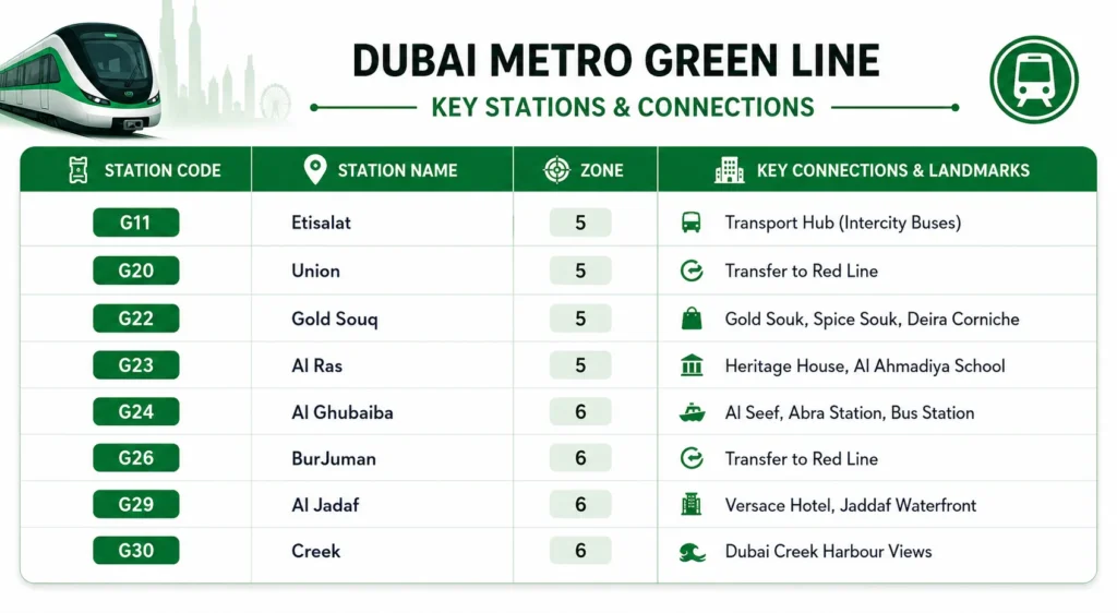
Dubai Metro Green Line Map and Stations
Zone 7
- Etisalat by e&
- Al Qusais
- Dubai Airport Free Zone
- Al Nahda
- Stadium
- Al Qiyadah
- Abu Hail
- Abu Baker Al Siddique
- Salah Al Din
Zone 6
- Union (Interchange – Red Line)
- Baniyas Square
- Gold Souq
- Al Ghubaiba
- Sharaf DG
- BurJuman (Interchange – Red Line)
Zone 5
- Oud Metha
- Dubai Healthcare City
- Al Jadaf
- Creek (Terminus)
Interchange Stations Between Red and Green Lines
If you’re using the Dubai Metro for the first time, changing between the Red Line and Green Line is much easier than most people expect. The two Interchange Stations (Union Station and BurJuman Station) allow passengers to switch lines without leaving the paid area, so your metro journey continues smoothly under the same fare system with a single fare based on the total zones travelled.
Union Station
From my experience, Union Station is one of the busiest stations on the metro network. Located in Deira, it features clear English signage and Arabic signage, while walkways, escalators, and connected platforms make the platform connection simple. The walk usually takes around 2 to 3 minutes, with quick access to Al Rigga, Gold Souk, and Dubai’s commercial district.
BurJuman Station
BurJuman Station is ideal if you’re travelling between the airport area and Bur Dubai or exploring the city’s heritage zone. Like Union, the platforms are linked inside the paid area, allowing a convenient line transfer in about 2 to 3 minutes. The station also offers lifts, escalators, air conditioning, retail kiosks, and customer service points. Simply tap your card once at the entry gate and again at the exit gate, and the system automatically calculates your fare.
Pro Tip
Future Dubai Metro Lines:
The Dubai Metro continues to expand, and from what I’ve followed over the past few years, these upcoming projects will make the metro network even more connected. The Future Dubai Metro Lines, including the Blue Line and Gold Line, are part of Dubai’s long-term metro expansion strategy to strengthen the transport network, improve rapid transit, support public transport, and enhance urban mobility. These new metro lines are designed to improve city connectivity, reduce dependence on private vehicles, and provide smarter transportation for residents and visitors.
Blue Line
The Blue Line is currently under construction and is scheduled to open in 2029. This metro project will add a 30 km corridor with 14 new stations, extending from Creek, the current Green Line terminus, to International City and Dubai Silicon Oasis. The route will include multiple interchange points with both the Red Line and Green Line, making metro interchange easier across the city. Planned stations such as Dubai Creek Harbour, Academic City, and Mirdif will provide better access to rapidly growing residential areas and growing residential communities that currently rely on buses and taxis. Once completed, the line will further strengthen Dubai’s rail network, improve daily commute, and support smoother passenger travel.
Gold Line
The Gold Line was announced by the Roads and Transport Authority (RTA) on 22 April 2026 as Dubai’s fourth metro line. It is scheduled to open in 2032 and represents the next phase of metro development and network expansion. The project supports the Dubai 2040 Urban Master Plan, which focuses on sustainable transport, smart mobility, and expanding the Dubai Metro to 96 stations, with long-term plans reaching 140 stations. Together, these future developments will modernize the city’s infrastructure, improve integrated transport, expand the railway system, and create a more efficient future transportation network for Dubai.
Conclusion
Whether you’re a tourist or a daily commuter, the Dubai Metro Map is the easiest way to understand Dubai’s metro network and plan efficient journeys. From the Red Line and Green Line to the upcoming Blue Line and Gold Line, every route is designed to improve city connectivity, urban mobility, and public transport across the emirate. With clearly marked metro stations, interchange stations, zone information, and an easy-to-follow interactive map, navigating Dubai becomes simple, fast, and hassle-free. Before you travel, take a moment to check the latest Dubai Metro Map, station updates, and route information to save time and enjoy a smoother journey. Mus Know that you need a nol card if you want to travel in dubai metro or busses. also you have to check nol card balance to travel in dubai metro, tram or busses.
Faq's About Dubai Metro Map
Dubai Metro fares are calculated based on the number of zones you travel through. The network is divided into 7 zones. Travel in zone 2 costs AED 3 with the Silver Zero card, AED 5 in zone 2, and AED 7.5 in zone 3 or more. There are also special prices for Red Tickets (paper tickets) and Gold Class (premium cabins).
Yes, Dubai Metro offers a daily fare cap of Dh14 for the Silver Zero card and Dh7 for the Blue Zero card. Gold cardholders have a daily limit of AED 28. This means you won’t pay more than a limited amount no matter how many trips you make in a day. In addition, monthly passes are available: Silver Silver Pass is Dh350 for all zones, while Gold pass is Dh500.
Yes, students, senior citizens (aged 60+), and serious people can get 50% off all Dubai Metro fares with a personalized Blue Nol card. To apply for this card, eligible individuals must visit the RTA Customer Care Center with the required documents (student ID, Emirates ID or disabled card proving age).
Of course, Dubai Metro operates on holidays as well. However, hours of operation may change during holidays, national days, and other events. It is recommended to check the RTA schedule or the latest Dubai Metro updates before traveling for the holidays.
Yes Every metro train in Dubai has separate cabins for women and children to ensure privacy and comfort. It is usually located at the end of the train and is clearly marked with pink labels and floor stickers. People found in these salons can be fined Dh100.
Yes, you can carry up to two pieces of luggage on the Dubai Metro: one large suitcase (maximum 81 × 58 × 30 cm) and one piece of hand luggage (maximum 55 × 38 × 20 cm). All luggage should be placed in the designated baggage areas available inside each metro carriage.
The Red Line initially ran along Sheikh Zayed Road, connecting key destinations such as the airport, Burj Khalifa and Dubai Beach. The Green Line covers older parts of Dubai such as Deira, Bur Dubai, and Al Jadaf. Both lines intersect at Union and BurCuman stations for convenient transfers.
Yes, the Dubai Metro is one of the safest public transport systems in the world. It has CCTV cameras, service providers, and separate cabins for women and children. It is well maintained, regularly patrolled and safe for solo travellers, women and families.
Red Line trains run every 3 minutes 45 seconds during peak hours and every 5 to 7 minutes during peak hours. Green Line trains run every 5 to 7 minutes during peak hours and every 7 to 9 minutes during peak hours. Frequencies are higher during Ramadan and special events.
Yes. Most Dubai Metro stations have dedicated taxi stands located near the station exits. If you prefer, you can also book a taxi through the Careem or S’hail app and have it pick you up directly from the station.